Drone technology is rapidly transforming agricultural practices, offering unprecedented precision and efficiency. This integration promises to revolutionize how crops are monitored, managed, and harvested, ultimately impacting yield, cost, and environmental sustainability. From precise spraying to real-time crop analysis, drones are poised to reshape the future of farming.
Existing farming methods often face challenges in achieving optimal yields and minimizing environmental impact. Current practices can be inefficient, leading to wasted resources and potentially harmful environmental consequences. Drones, equipped with advanced sensors and sophisticated analysis tools, can offer a more precise and targeted approach to address these limitations, ultimately improving the overall efficiency and sustainability of agricultural operations.
Existing Farming Practices and Their Needs
Traditional farming methods, while fundamental to food production, often face significant limitations in terms of efficiency, precision, and environmental impact. These challenges are amplified by increasing global demand for food and the need for sustainable practices. Modern agricultural technologies, including drone integration, offer a pathway to address these limitations and pave the way for a more resilient and productive agricultural sector.Current farming practices frequently struggle with issues like uneven resource distribution, pest infestations, and the difficulty in accurately assessing crop health.
This necessitates a shift towards more precise and data-driven approaches, where drones can provide real-time insights and targeted interventions.
Challenges and Limitations of Current Farming Methods
Current farming methods often lack the precision required for optimal resource allocation. This can lead to inefficiencies in water and fertilizer use, impacting both yield and environmental sustainability. In addition, traditional pest control methods can be ineffective and environmentally damaging, requiring alternative, targeted solutions. Traditional land surveying and crop monitoring are often time-consuming and labor-intensive, hindering timely responses to emerging issues.
Need for Enhanced Precision and Efficiency in Modern Farming
The demand for increased food production necessitates more precise and efficient farming techniques. Modern farming practices must adapt to meet the growing global population’s needs while minimizing environmental impact. Enhanced precision in irrigation, fertilization, and pest control can significantly improve yields and resource utilization. Data-driven insights provided by drone technology are essential in achieving this enhanced efficiency.
Examples of Traditional Farming Practices Improvable with Drones
Traditional irrigation techniques often lead to water waste due to uneven distribution. Drones equipped with sensors can provide real-time data on soil moisture levels, enabling targeted irrigation, thereby optimizing water usage. Traditional pest control methods can be broad-spectrum and environmentally harmful. Drone-based pest detection and targeted application of pesticides can minimize environmental impact while maintaining crop health.
Explore the different advantages of cost-effectiveness of using drones in large-scale farming that can change the way you view this issue.
Traditional crop monitoring relies on visual inspection, which can be subjective and time-consuming. Drone imagery provides objective data for early disease detection and precise identification of problem areas.
Crops and Livestock Supported by Drones
Drones are now supporting a diverse range of crops and livestock. Precision agriculture techniques are employed for various field crops, including corn, soybeans, and wheat. Livestock monitoring, through drones equipped with thermal imaging, helps track animal health and movement patterns, aiding in early disease detection and management. This includes monitoring herd health, pasture conditions, and animal behavior.
Environmental Impacts of Existing Farming Practices
Existing farming practices can have significant environmental impacts, including water pollution from fertilizer runoff, soil erosion from unsustainable tillage practices, and greenhouse gas emissions from livestock operations. Drones can help mitigate these impacts by providing data-driven insights into optimizing resource use and minimizing environmental damage. For example, drones can map areas for targeted fertilizer application, reducing overall fertilizer use and minimizing water pollution.
Data Collected by Drones in Agriculture
| Data Type | Description | Usefulness |
|---|---|---|
| High-resolution imagery | Detailed visual representation of crops and fields | Identifying crop stress, disease, and pest infestations; assessing overall crop health; and mapping field boundaries. |
| Multispectral imagery | Data on reflectance from different wavelengths | Determining crop vigor, identifying nutrient deficiencies, and assessing irrigation needs. |
| Thermal imagery | Measuring surface temperature | Detecting heat stress in plants or animals; pinpointing areas needing irrigation; and identifying animal health issues. |
| LiDAR data | High-resolution 3D mapping of the terrain | Creating detailed topographic maps, optimizing field layouts for precision agriculture, and assessing land suitability for different crops. |
| GPS data | Precise location information | Pinpointing specific areas of concern for interventions; enabling precise application of inputs like fertilizers and pesticides; and tracking livestock movement. |
Drone Technology Integration

Agricultural practices are rapidly evolving, and drone technology is emerging as a powerful tool for enhancing efficiency and precision in farming operations. Integrating drones into existing frameworks promises to revolutionize crop monitoring, yield prediction, and resource management, potentially boosting productivity and sustainability. This transformation is being driven by the drones’ ability to gather detailed data quickly and precisely, enabling farmers to make informed decisions based on real-time insights.
Drone Integration Procedures
Integrating drone technology into existing farming practices involves a phased approach. First, a comprehensive assessment of the farm’s current operations and specific needs is crucial. This includes identifying areas where drone technology can provide the most significant benefits, such as crop monitoring, pest detection, or irrigation optimization. Next, the selection of appropriate drone models and sensors is essential.
The chosen equipment should align with the intended tasks and the size of the farm. This selection process should consider factors like flight time, payload capacity, and image resolution to ensure optimal data acquisition. Careful planning of flight paths and scheduling is also vital to minimize disruption to ongoing farming activities.
Crop Monitoring and Yield Estimation
Drones equipped with high-resolution cameras and multispectral sensors can capture detailed images of crops at various stages of growth. These images can be used to monitor plant health, identify areas of stress or disease, and assess overall crop vigor. Analysis of the collected data allows farmers to pinpoint problem areas and adjust their management strategies accordingly. By comparing data from multiple flights, drones can also estimate yields with increasing accuracy.
For instance, data on plant density and canopy cover, coupled with historical yield data, allows for precise predictions of the final harvest, enabling farmers to optimize harvesting schedules.
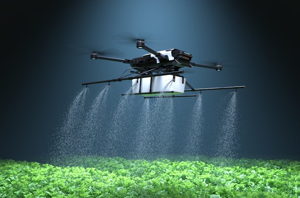
Precise Spraying and Fertilization
Drone-based spraying systems enable precise application of pesticides and fertilizers. Using GPS-guided navigation, drones can target specific areas within a field, minimizing environmental impact and optimizing resource utilization. This approach ensures that the right amount of treatment reaches only the affected area, reducing waste and minimizing the risk of harming beneficial insects or the environment. Precision spraying systems can also be integrated with variable rate technologies to deliver different amounts of spray to different parts of a field based on the specific needs of those areas, ensuring optimal crop health.
Livestock Management
| Step | Procedure | Expected Outcome |
|---|---|---|
| 1 | Deploy drones equipped with thermal imaging and/or video cameras to monitor livestock movement, behavior, and health. | Early detection of sick or injured animals, enabling timely intervention and minimizing disease spread. |
| 2 | Utilize GPS-enabled tracking systems to monitor animal location and movement patterns. | Improved livestock management by facilitating timely relocation and reducing grazing stress. |
| 3 | Analyze data from drones to assess herd density and distribution, providing insights for pasture management. | Optimized grazing patterns, leading to improved forage utilization and reduced environmental impact. |
| 4 | Conduct regular aerial surveys to assess animal weight and health, supporting proactive management decisions. | Precise monitoring of livestock weight and health, aiding in proactive measures for better herd management. |
This table Artikels the procedures involved in using drones for livestock management, highlighting the expected outcomes for each step.
Data Analysis and Interpretation
The data collected by drones requires careful analysis and interpretation to extract meaningful insights for informed decision-making. Software tools are employed to process drone imagery, enabling the identification of patterns and anomalies. Image analysis techniques, like spectral analysis, can differentiate between healthy and stressed plants. Combining this data with existing farm records and weather data provides a comprehensive picture of the farm’s current status.
This comprehensive analysis allows farmers to optimize irrigation schedules, fertilization plans, and pest control strategies, ultimately improving farm productivity and sustainability.
Benefits and Impacts of Integration
Drone technology is rapidly transforming agricultural practices, offering a suite of benefits that promise to enhance efficiency, reduce costs, and improve environmental sustainability. This integration, often termed precision agriculture, leverages data-driven insights to optimize resource allocation and maximize yields, ultimately impacting farmers and the wider food system.
Economic Benefits
Integrating drones into farming yields substantial economic advantages. Farmers can reduce input costs by precisely targeting applications like fertilizer and pesticides. This precision minimizes waste and maximizes the effectiveness of these crucial resources, directly translating into savings. Furthermore, the improved crop yields and reduced losses from diseases or pests lead to increased profitability. Drones enable proactive management of crops, preventing significant losses that can cripple a farm’s finances.
Increased Efficiency and Reduced Costs
Drones streamline various agricultural tasks, enhancing overall efficiency. For instance, real-time crop monitoring allows farmers to identify areas needing immediate attention, like pest infestations or nutrient deficiencies. This proactive approach prevents widespread damage, reducing the need for reactive measures that are often more expensive. Similarly, precise spraying with drones minimizes chemical use, reducing costs associated with inputs and minimizing environmental impact.
Automated data collection through drones reduces the labor required for manual assessments, freeing up human resources for other tasks.
Environmental Advantages of Precision Agriculture
Precision agriculture, facilitated by drones, promotes environmentally sustainable practices. Targeted application of resources like water and fertilizers eliminates waste, conserving these essential inputs. This approach is crucial for water conservation in regions facing drought or water scarcity. Drones also enable the early detection of environmental stressors, allowing for timely intervention and minimizing the negative effects on crop health.
Reduced pesticide use, achieved through targeted application, safeguards beneficial insects and biodiversity.
Social Impacts on Farmers
Drone integration can significantly impact farmers’ lives, both positively and potentially negatively. On the positive side, drones empower farmers with data-driven insights, empowering them to make more informed decisions and optimize their operations. Access to real-time information about crop health allows for proactive management, potentially reducing the risks of crop failures and financial losses. This enhanced decision-making capacity can lead to greater profitability and potentially improve the overall quality of life for farmers.
On the negative side, there’s a potential for job displacement in manual tasks previously performed by farm laborers. However, the potential for new roles in drone operation, data analysis, and maintenance may offset some of this impact.
Potential for Job Creation or Displacement
The integration of drone technology into agriculture presents a complex scenario regarding job creation and displacement. While some manual tasks, like aerial surveillance and spraying, may become automated, the demand for skilled labor in drone operation, data analysis, and maintenance will likely increase. The development of drone technology and precision agriculture will likely create new jobs in related sectors, requiring specialized skills in areas like data analysis and drone piloting.
However, it’s important to acknowledge the possibility of displacement in certain existing agricultural roles. Transitioning the workforce to meet the evolving demands of this new agricultural paradigm will require investments in training and reskilling programs.
Potential Cost Savings and ROI of Drone Integration
| Area | Cost Savings | ROI |
|---|---|---|
| Fertilizer application | 15-25% | 1.5-2.5x |
| Pesticide application | 10-20% | 1.2-2x |
| Irrigation management | 5-15% | 1.1-1.5x |
| Crop monitoring | 10-20% | 1.2-2x |
| Disease/pest detection | 10-20% | 1.2-2x |
Note: Cost savings and ROI figures are estimates and can vary depending on specific farm operations, drone models, and other factors.
Challenges and Limitations
The integration of drone technology into existing farming practices, while promising, faces significant hurdles. From technical limitations in drone capabilities to regulatory complexities and data management challenges, obstacles exist that could hinder widespread adoption. Addressing these challenges is crucial for realizing the full potential of drone agriculture.
Technical Challenges in Drone Integration
Several technical hurdles complicate the seamless integration of drones into agricultural workflows. Drone flight stability and precision are paramount for accurate data collection. Weather conditions, such as wind and rain, can significantly impact flight stability and data accuracy. Varied terrain and crop types also present unique challenges, requiring specific sensor and flight path adjustments. The processing power required for real-time data analysis and decision-making is substantial, and this processing power needs to be balanced with the drone’s payload capacity.
The need for advanced sensors and cameras that can capture high-resolution images and multispectral data is also a significant technical challenge.
Regulatory Hurdles and Legal Considerations
Navigating the regulatory landscape for drone operation in agriculture presents substantial challenges. Different jurisdictions have varying regulations regarding drone operation, including flight altitudes, permitted airspace, and required certifications. Obtaining necessary permits and licenses can be complex and time-consuming, often requiring significant upfront investment. Liability concerns and insurance requirements for drone-related incidents must also be addressed. Data privacy and security regulations also need careful consideration, especially when dealing with sensitive crop and field information.
Limitations of Current Drone Technology
Current drone technology has limitations that affect its effectiveness in agricultural applications. Battery life is often insufficient for comprehensive data collection over large areas. The size and weight of drones can restrict their maneuverability in challenging environments, like dense crops or rough terrain. The quality and resolution of imagery and sensor data can vary depending on the drone model and environmental factors.
Connectivity issues and communication failures between the drone and ground control stations can interrupt data transmission and lead to incomplete or inaccurate data.
Data Management and Analysis Challenges
Data generated by drones requires sophisticated management and analysis systems. The sheer volume of data collected can overwhelm existing infrastructure. The integration of drone data with existing farm management systems is often a complex process. The accuracy and reliability of the data are essential for effective decision-making. Developing algorithms for extracting meaningful insights from the vast amount of data is a significant challenge.
The interpretation of multispectral imagery and other data requires skilled personnel.
Potential Safety Concerns
Drone operation in agricultural settings raises potential safety concerns. The risk of collisions with livestock or equipment must be mitigated. Pilot training and certification are crucial to ensure safe operation. Drone malfunction or loss of control can result in damage to crops or property. The use of drones near populated areas or sensitive environments requires careful consideration of potential safety risks.
The potential for interference with other airspace users also needs careful management.
Limitations of Various Drone Technologies for Agriculture
| Technology | Limitation | Mitigation Strategy |
|---|---|---|
| Fixed-wing drones | Limited maneuverability in complex terrains; shorter flight times | Employing GPS-guided flight paths and optimizing flight plans; utilizing advanced battery technologies. |
| Multirotor drones | Susceptibility to wind and turbulence; shorter flight times; payload capacity limitations | Utilizing advanced flight control systems; implementing robust weather monitoring; employing specialized payload designs for increased capacity. |
| Hybrid drones | Cost and complexity of design and maintenance | Employing cost-effective design approaches; streamlining maintenance procedures; optimizing drone deployment strategies. |
| VTOL (Vertical Take-off and Landing) drones | Limited payload capacity; battery life issues | Developing advanced battery technologies; optimizing payload designs; integrating advanced flight control systems. |
Future Trends and Developments
Agricultural drone technology is rapidly evolving, promising to revolutionize farming practices and precision management across various sectors. The integration of advanced sensors, artificial intelligence, and autonomous systems is poised to significantly enhance efficiency, productivity, and sustainability in agriculture. This evolution necessitates a deep understanding of the challenges and limitations inherent in current systems, and the potential advancements to address them.
The Future of Drone Technology in Agriculture
Drone technology is poised to become an integral part of modern agriculture. Expect to see a rise in the use of drones for tasks such as crop monitoring, livestock management, and precision spraying. This transition reflects the growing demand for efficient and targeted agricultural practices.
Potential Advancements in Drone Technology and Sensor Capabilities
Innovations in drone technology are driving the development of more sophisticated sensors. These advanced sensors are capable of capturing highly detailed data, allowing for more precise analysis of crops and livestock. High-resolution cameras, multispectral sensors, and thermal imaging are key examples. Furthermore, the development of lighter, more agile drones is expected, allowing for improved maneuverability and efficiency in complex agricultural environments.
Examples of Emerging Technologies and Their Applications
Emerging technologies, such as hyperspectral imaging, are revolutionizing crop monitoring. Hyperspectral imaging provides detailed information about plant health, enabling early detection of stress and disease. This early detection allows for timely interventions, minimizing crop losses and maximizing yield. Simultaneously, advancements in LiDAR (Light Detection and Ranging) are enabling the creation of detailed 3D maps of farmlands, crucial for precision agriculture and site-specific management.
Integration of AI and Machine Learning with Drone Data
The integration of artificial intelligence (AI) and machine learning (ML) algorithms with drone data is a key driver of future advancements. AI can analyze the massive amounts of data collected by drones, identifying patterns and anomalies that might indicate disease, pest infestations, or nutrient deficiencies. This allows for proactive management and targeted interventions, leading to improved yields and reduced input costs.
Furthermore, AI can be used to optimize flight paths and scheduling, maximizing efficiency and reducing operational costs.
Potential for Autonomous Drone Operations in Farming
Autonomous drone operations are becoming a tangible reality in agriculture. This involves drones that can perform tasks without human intervention, significantly increasing efficiency and reducing labor costs. These drones can autonomously spray crops, monitor livestock, and inspect fields, providing continuous and real-time data collection. This autonomous capability can also help with remote or challenging terrains, improving accessibility and coverage.
Future of Drone Technology for Precision Livestock Management
Drone technology is also transforming precision livestock management. Drones equipped with thermal imaging cameras can monitor the health and well-being of livestock, detecting signs of illness or stress. This early detection enables proactive intervention, reducing losses and improving animal welfare. Furthermore, drones can be used to track individual animals, providing valuable data for optimizing feeding strategies and herd management.
Illustration: Potential Evolution of Drone Technology for Agriculture in the Next 5 Years
A hypothetical example illustrates the potential evolution of drone technology in agriculture over the next five years. Imagine a scenario where drones equipped with advanced hyperspectral cameras autonomously monitor a large field. The collected data is analyzed by AI algorithms that identify subtle signs of nutrient deficiencies. Based on this analysis, the drone then autonomously directs a precision fertilizer application to specific areas within the field, thereby optimizing nutrient use and minimizing waste.
This represents a significant leap forward from the current practices, emphasizing the increased automation and data-driven precision expected in the coming years.
Closure

The integration of drone technology with existing farming practices presents a compelling opportunity to enhance efficiency, reduce costs, and minimize environmental impact. While challenges like regulatory hurdles and data management exist, the potential benefits for both farmers and the environment are substantial. The future of agriculture appears increasingly intertwined with drone technology, promising a more sustainable and productive food system.